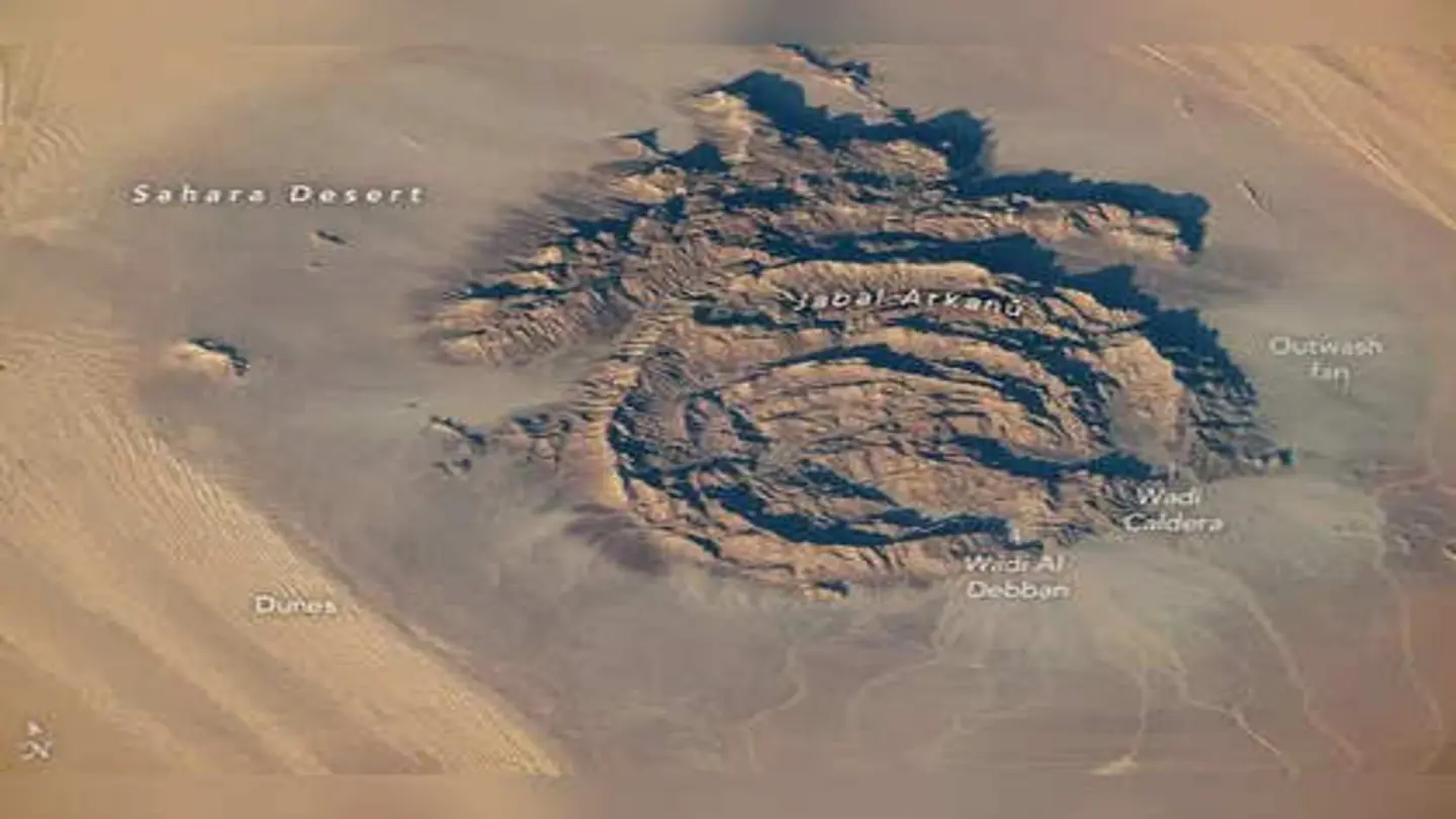
NASA has released a captivating image of Jabal Arkanu, a unique ring-shaped geological feature located in Libya’s Sahara Desert, as seen from the International Space Station (ISS). The image showcases the stark beauty and geological significance of this remote desert region.
Jabal Arkanu, also known as Gebel Arkenu, is situated in the Kufra Basin of southeastern Libya. The prominent ring structure, approximately 10 kilometers in diameter, has long intrigued geologists. The origin of the structure is debated, with some theories suggesting it is the result of an ancient meteorite impact, while others propose a volcanic origin or a more complex geological process involving uplift and erosion.
Geological Significance
The Sahara Desert, despite its arid conditions, holds a wealth of geological history. Jabal Arkanu stands out due to its unusual circular shape and the presence of diverse rock formations. The surrounding terrain is characterized by vast sand seas and rocky outcrops, making the ring structure even more visually striking. Remote sensing data and fieldwork are crucial in unraveling the mysteries behind its formation.
NASA’s image provides a valuable perspective on the region’s topography and geology. The ISS offers a unique vantage point for capturing such features, allowing scientists to study Earth’s surface in detail. Such images are not only visually stunning but also contribute to a better understanding of our planet’s geological processes.
Exploration and research in remote areas like Jabal Arkanu are challenging due to the harsh environment and logistical difficulties. However, advancements in satellite technology and remote sensing are making it easier to study these regions. Detailed analysis of the rock composition and structural features is necessary to determine the exact origins of the ring structure.
The image released by NASA underscores the importance of space-based observations in Earth science. The ISS serves as a crucial platform for monitoring environmental changes, studying natural disasters, and documenting geological features. These observations contribute significantly to our understanding of Earth’s dynamic systems.
The Jabal Arkanu image is a reminder of the diverse and often surprising landscapes that exist on our planet. It invites further exploration and research into the geological history of the Sahara Desert and the processes that have shaped its unique features. The image will undoubtedly inspire scientists and explorers alike to delve deeper into the mysteries of our planet.
The detailed imagery from the ISS helps in monitoring changes over time, providing critical data for studying geological evolution and environmental impacts in such remote regions. Future research missions may involve on-site investigations to gather more detailed data and samples, further advancing our understanding of Jabal Arkanu and its surroundings.
Image Source: Google | Image Credit: Respective Owner